
Extension of the scope of the advanced data options towards GIS / SDI
The project’s GeoServices, available online as a publicly-accessible first release, complement the advanced data options with a range of services in the realm of integrated geographic information systems (GIS). The GEO Services interface allows the interested public, stakeholders, and researchers to combine the project’s citizen science based data in an intuitive way with existing scientific data, and to see data and outcomes in a geo-spatial dimension.
The core features and possibilities of the SPOTTERON GeoServices platform are:
- to offer simple access to geographic data for a wider audience, including researchers and public institution
- to provide seamless integration with existing spatial data infrastructures (SDI) through standardized APIs, allowing external data repositories or digital twins to connect and use the citizen science submitted data via automation
- to use future-proof technologies for advanced geodata processing
- to enable high levels of data security for personal, restricted, and sensitive data
- to actively support a commitment to free and open-source software (FOSS) solutions as well as consensus-driven standards and technology development
- to enable exchange and integration of Citizen Science data in Digital Twins and other forms of external platforms
The GeoServer infrastructure is running on our IT infrastructure, including ongoing maintenance of the system and software for ongoing compatibility, stability, and security.
Purpose of project’s GIS/SDI Infrastructure
The project's GeoServices platform fulfill multiple purposes, four of which can be summarized in the well-known FAIR principles of Findability, Accessibility, Interoperability, and Reusability.
- Findability allows humans and computers to find and query geo-data resources through standardized metadata formats and online catalogues.
- Accessibility informs users on how to access the actual data, potentially including authentication and authorization.
- Interoperability acknowledges that data can be accessed through software interfaces following open communications standards and data formats.
- Reusability as the main goal of these principles addresses the reuse of data in contexts and for purposes beyond those for which it was initially collected.
As a consequence, following these principles, published data becomes available to a wider audience, and enables data access for researchers, public institutions, and policy makers using established GIS clients and tools. Hosted datasets integrate easily into publicly available infrastructures, to cross-reference and visualize with datasets from a larger ecosystem of scientific research including those published under the EU INSPIRE directive.
The EU INSPIRE Directive [https://interoperable-europe.ec.europa.eu/collection/inspire] aims at "creating a European Union (EU) spatial data infrastructure for the purposes of Community environmental policies and policies or activities which may have an impact on the environment." The Directive has been in full effect since 2019 and enables "the sharing of environmental spatial information among public sector organizations and better facilitate public access to spatial information across Europe." As an example of this infrastructure, the European Marine Observation and Data Network (EMODnet) brings together more than 6000 resources, including datasets, maps, and services, which are freely available and accessible online.
In addition, the implementation of new services brings extended support and rapid development for new application scenarios and use cases through advanced GIS technologies and a flexible infrastructure. Ranging from stylized map visualizations with multiple customizable layers for simple access to tiled and vectorized map data for efficient, high-performant web and mobile applications to direct access to the underlying data model for automated data processing workflows, the project's GIS infrastructure is built on industry best practices and covers a wide range of current and future applications.
The GIS infrastructure comprises components and services from a multitude of free and open-source software projects and initiatives. With a commitment to interoperability, open standards, and consensus-driven development, open-source communities worldwide work towards continuous improvement of GIS technologies, making technical knowledge accessible to everyone, and ensuring continued access to scientific information for academia, public and private entities, and interested individuals.
How Access to the GeoServices is Provided
Data access is provided via standardized web services and in multiple widely supported data formats, where applicable, including Geography Markup Language (GML), JSON, Google Earth (KML), and plain text (CSV). This ensures support for the widest possible range of contemporary GIS clients and tools, including free and commercial desktop and web clients.
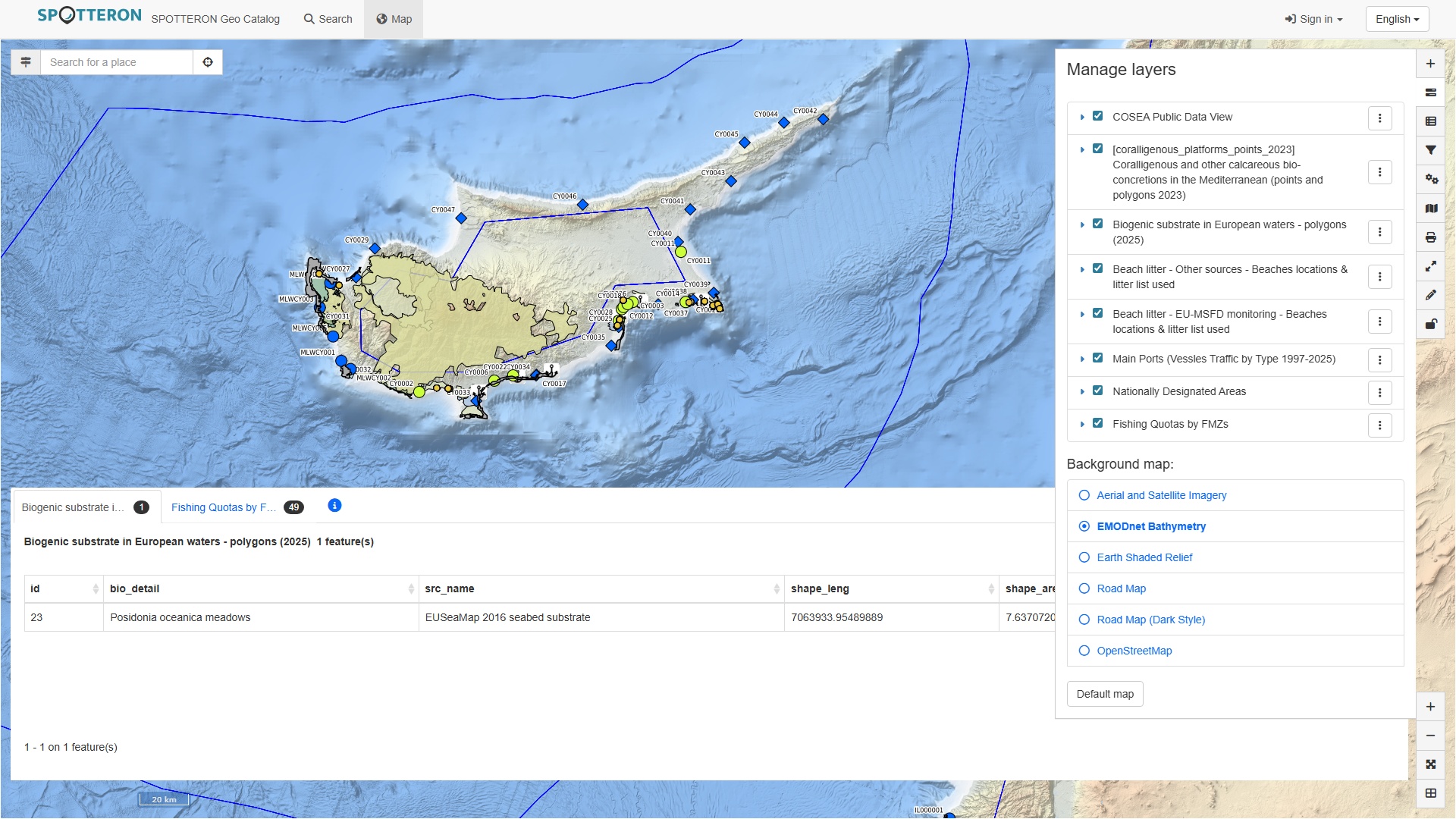
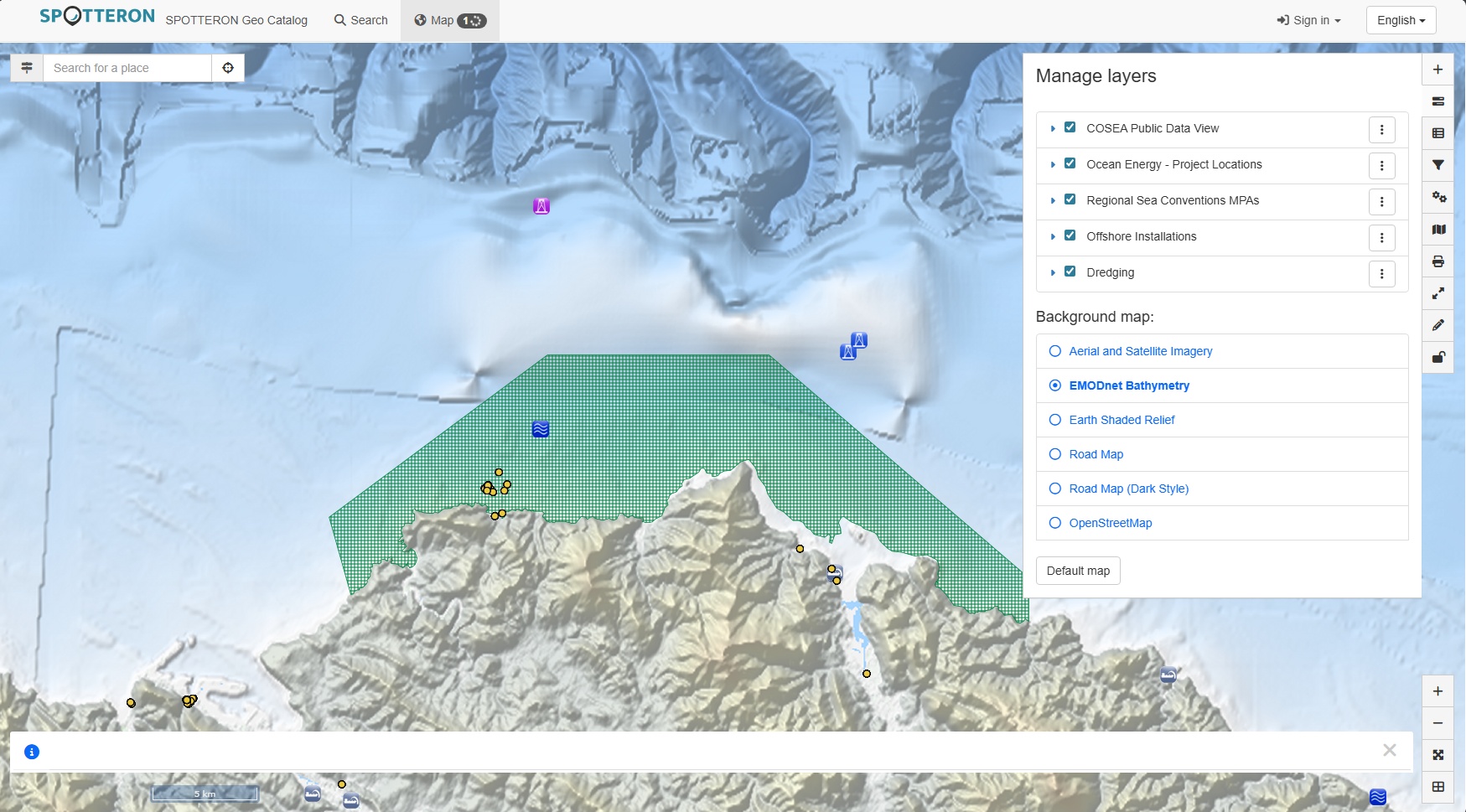
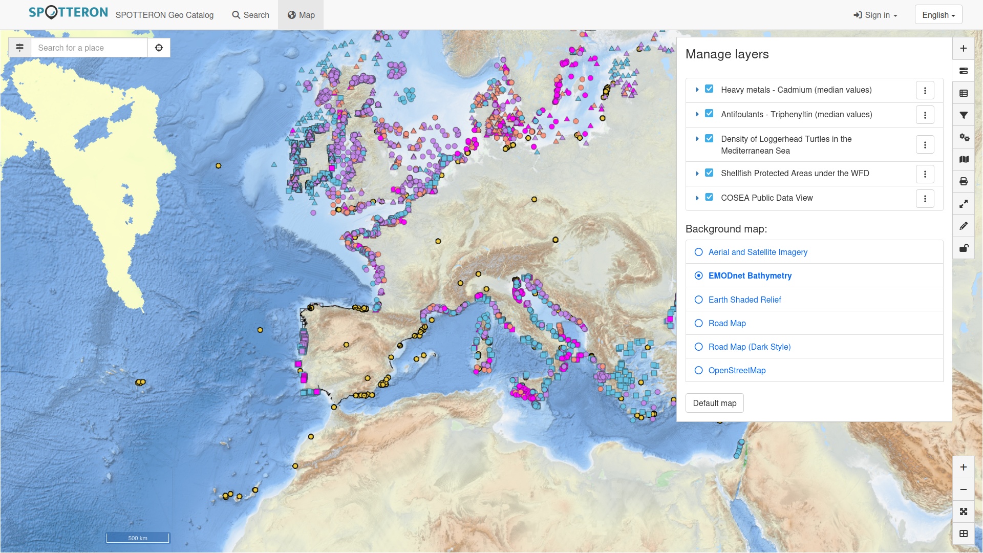
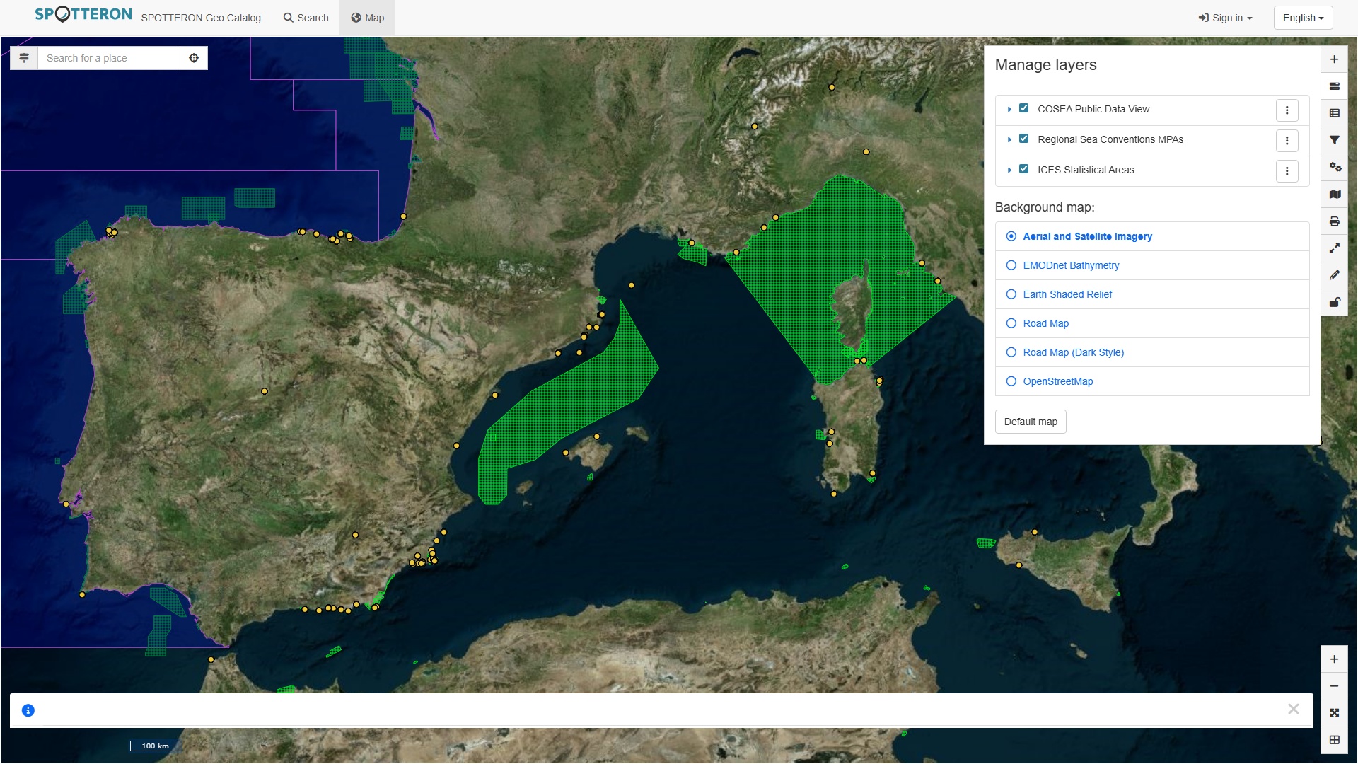
An online metadata catalogue serves as a publication endpoint for hosted data and integrates resources from the EU INSPIRE SDI, such as EMODnet. Integrated into the catalogue service is a web GIS client for online viewing of indexed and external data. Through the web client, or any other GIS tool of choice, data can be conveniently explored online and downloaded in various commonly used formats for offline processing.
In addition, the metadata catalogue mediates direct access to services and datasets for advanced queries and automated processing. Standardized interfaces allow catalogued data to be efficiently searched, filtered, and transferred by a wide range of compatible GIS clients and tools. In this way, the catalogue and service endpoints provide simple, flexible, and robust support for current and future use cases, ranging from preliminary data exploration to building complex models and pipelines.
Pillars of project's GIS Infrastructure
Underlying most other services, a geospatial database facilitates the storing, indexing, and querying of geospatial data. This database indexes information based on its geographic position or extent, and is capable of efficiently performing complex operations involving spatial relations. Typical examples of such operations include filters limiting datasets to certain areas, such as a country, finding nearest spots to a given location, translating (reverse geo-coding) a geographic location to its street address, or route planning. With full control of the IT infrastructure and database, P3 is able to implement specialized and highly efficient database operations that allow for tailor-made geo-data processing and visualizations.
At the heart of the geo-spatial infrastructure, a map server acts as the central service that publishes geographic data and map visualizations using open standards. Access is possible with any compatible GIS client, including desktop and web applications from commercial vendors and open source initiatives. The map server covers the industry-established OGC Web Services, featuring the widest support in tools and applications, as well as the more recent OGC API collection of standards, developed for modern web applications. In this way, the project's GIS infrastructure is interoperable with the largest possible set of standards-conformant GIS clients and well-equipped for the future of distributed geo-technologies.
Map services complement each other, and offer a multitude of features aimed at different application scenarios and use cases. Where applicable, different formats are supported for data transfers for increased flexibility at the data congestion level. Map server and database support custom attributes for geo-data and facilitate application and project specific information models, making it an ideal solution for integrating spot data with standardized information schemas, e.g. from geography and web technologies.
SDI Integration
To foster the FAIR principles of Findability, Accessibility, Interoperability, and Reusability, datasets, maps and services provided by SPOTTERON are announced through a geo-catalogue service. Metadata annotations provide the necessary contextual information to make datasets, maps, services and other resources find-able and accessible without prior knowledge of their existence or location. Common vocabularies from different sciences serve as metadata keywords to indicate related topics and allow researchers to query large catalogues for relevant resources, fostering reuse beyond their initial publication and purpose.
Standardization of catalog metadata and programmable catalogue interfaces ensure interoperability in a distributed, heterogeneous network of geo-information systems and allow for the integration of larger spatial data infrastructures such as those provided by the EU INSPIRE directive. Interoperability extends both ways, and supports the sharing of resource metadata provided by the project’s Citizen Science app toolkit to other geo-catalogues, as well as integrating external catalogue metadata into the project's GeoServices platform.
This external metadata thus becomes find-able and accessible through the catalogue and is easily reusable, e.g. in the integrated web map viewer or any contemporary desktop GIS client. The web map viewer in particular provides an easy preview of datasets hosted on our GIS infrastructure, and can interactively visualize customizable sets of map layers from the project’s app data-set as well as other data providers.
Map visualizations are complemented by additional map data from external services, such as street maps and aerial/satellite imagery.
Data Security
All data available through the project’s GeoServices platform are published following the same concise security policies as in the project’s app. A sophisticated Data Security Layer, developed by P3 for the use in Citizen Science App toolkit, is already in place and it extends also to data published through the new GIS infrastructure in order to protect personal, restricted, and/or sensitive information. Public data is provided without restrictions; Sensitive data is only accessible by authorized personnel as part of their project engagements.
Are you interest using advanced GeoServices in your Research, Citizen Science, or Community Science project? Reach out to us!