Better science data over time in Citizen Science Apps: introducing the Nearby-Spot feature

Tuesday, 16 March 2021 21:23

As a project partner on the SPOTTERON platform, you can now gently guide the Citizen Scientists contributing to your project to make better, more accurate observations in the Apps, thus making the data you're trying to obtain better and easier to manage.

You might already be familiar with the Spot-Update feature, which allows participants in your Citizen Science project to make observations of a specific plant, landscape, etc., and create timelines over extended periods to gather valuable data during its course. The data of ongoing contributions in the Citizen Science App are linked in reference to each other by submitting them as spot updates in the Citizen Science App. This feature can be used for chronological observations and record developments and changes on a location.
Read all about the "Spot Timelines" feature here on our Blog.
While this timeline feature has been on the SPOTTERON platform for quite some time, not all users have been aware of the advantages of posting a Spot update rather than a new spot, especially when a Citizen Science App has been just launched.

To foster ongoing observations on a single data point, together with the international CostSnap project, we've developed the Nearby Spot feature, a brilliant little helper within the App that scans the user's surroundings for any already existing Spots that might need updating. 
These Spots can be either your own or those of other users, such as a particular tree in a park that many people pass every single day. Instead of hundreds of people creating a new spot of the same tree, people can add their observations to the existing one, with the apparent advantages.

Adding a Spot Update with the Nearby Spot feature is easy as pie.

When you click on the plus button to add a new observation, instead of the usual add-spot-dialogue, a new window pops up. It shows you all the existing Spots within a certain radius with a Citizen Science project.

ScreenShot NearbySpot Dialogue
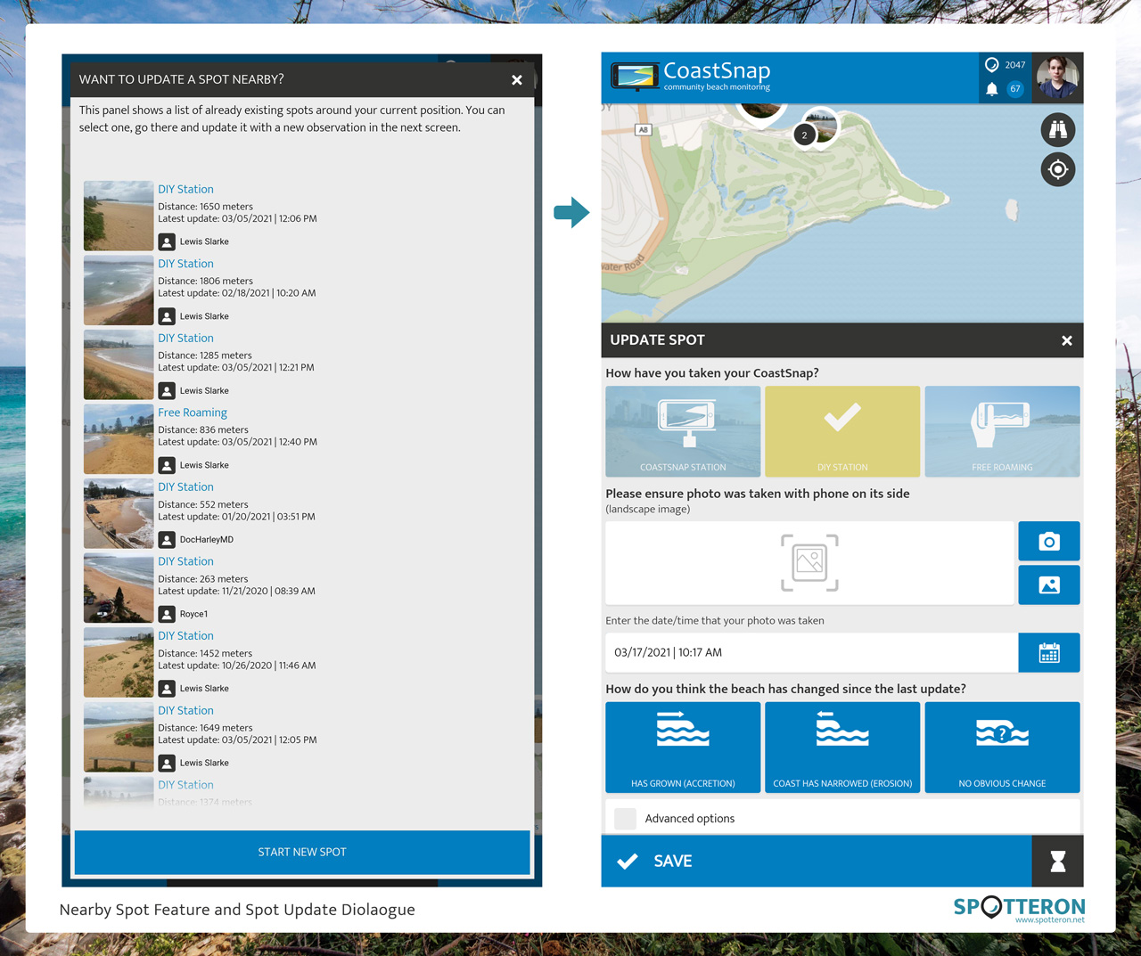
Example from the CoastSnap Citizen Science App: a list of Nearby Spots suggested for updates. After choosing a spot to update, the Update Dialogue pops up.

This radius can be defined individually for every project. Still, we recommend it to be about two kilometers, as it balances out any inaccuracies regarding location service and GPS that might occur on a mobile device. It's also a realistic walking distance a citizen scientist might want to walk at a leisurely pace within less than half an hour - something we at SPOTTERON warmly recommend doing anyway, especially in the current times of lockdowns and travel restrictions.

Making nature observations over more extended periods is fun!

Since a spot update is connected with the original spot, adding updates rather than new Spots helps obtain a neat set of linked data. Within the Citizen Science App itself, users can swipe between the chronological Spot Updates and discover how a place, species, or object develops over time.

ScreenShot Detail Updates

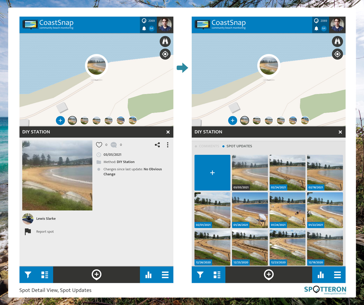
Example from the CoastSnap Citizen Science App: Spot Detail View of the latest Spot, and Timeline of all the Spot Updates.


Finally, it is a truly gratifying experience for the citizen scientist to have your Spots updated by others in the Community! Working together is an essential trait in Citizen Science, not only between projects on the collaborative SPOTTERON platform but also between Citizen Scientists in your App.

This newly developed feature is part of our unique "Feature Ecosystem" and is available for all projects running on the SPOTTERON platform. As always, it can be utilized by existing and new projects without any extra development costs and works right from the start of a fresh App.

Example Horizon Europe / Horizon 2020 Collaborations

App Icon
Horizon 2020 Invasive Species Monitoring App

The IPM-Popillia Horizon 2020 project aims to address the challenge of a new risk to plant health in Europe's agriculture and food safety: the invasion of the Japanese Beetle, Popillia japonica. This invasive species was introduced accidentally to mainland Europe in 2014 and can quickly spread by transportation and trade. As a species with a wide range of feeding plants, P. japonica threatens the entire agricultural sector, urban landscapes, and biodiversity in invaded areas.

Learn more about
IPM Popillia | Integrated Pest Management of the Japanese Beetle
App Icon
Horizon Europe Citizen Science App

EFFECTIVE, a Horizon Europe initiative, targets the emerging threat to the EU's Mediterranean Blue Natural Capital. By leveraging advanced science, technological nature-based solutions, digitalization, and social implication, the project aims to develop a comprehensive scientific knowledge base and practical guidance for the application of Ecosystem-Based Management to promote large-scale marine protected areas establishment in the European seas.

Learn more about
EFFECTIVE | Protection and Restoration Management of Mediterranean Marine Protected Areas
App Icon
Horizon Europe Citizen Science App

TRANSEATION, funded by Horizon Europe, aims to validate a new level of ecosystem-based management by integrating social implication digitalization and nature-based solutions to safeguard and restore marine ecosystem health and services. The project focuses on demonstrating the effectiveness of marine and coastal hybrid blue-grey infrastructures and developing digital tools for monitoring, analysis, and social involvement, addressing societal challenges and promoting sustainable management practices.

Learn more about
TRANSEATION | Advancements through Hybrid Blue-Grey Infrastructures in Marine and Coastal Areas
App Icon
Horizon 2020 Citizen Social Science App

In Europe and globally, substantial numbers of young people are at risk of social exclusion. Therefore, there is a pressing need to develop more knowledge and innovation to create inclusive and youth-friendly societies. The Horizon 2020 R&I Project YouCount contributes to these needs by developing 'actionable' knowledge for social inclusion of disadvantaged youths in the European Union and creating better means for social inclusion through citizen social science.

Learn more about
YouCount | Youth Citizen Science
App Icon
Horizon 2020 Citizen Science App

The impact of plastic pollution on soil health is largely unknown. However, the amounts of plastic entering soils are equal to or possibly even more significant than those entering our rivers, seas, and oceans. MINAGRIS, an EU Horizon 2020 funded project, will investigate how plastic affects soil biodiversity, soil functions, associated ecosystem services, and agricultural productivity.
Learn more about
MINAGRIS | Micro and Nanoplastics in Agricultural Soils
App Icon
Health Citizen Science App
University Medical Center Schleswig-Holstein, Kiel University Institute of Medical Psychology and Medical Sociology

StreetMind contributes to a better understanding how environmental factors like urbanicity or climate change influence how individuals across Europe and the world feel, act, and behave. Participants make up their minds with fellow citizens and scientists and share their daily experiences of their surroundings and the environment where they live, work, and interact.

Learn more about
StreetMind

Short News

  • New study from BiciZen project: "BiciZen: Lessons in the Development of a Crowdsourcing Mobile App to Make Cities More Bikeable" published in Journal of Participatory Research Methods. More studies available under the publication page here.

    in Shortnews
  • Roadkill project has made wonderful short videos for the citizen scientists! The videos include the Roadkill App functions regarding how to confirm & comment on the spots and how to best take the photos for the project. The videos (in German) are available in the "Österreich forscht" blog here. 

    in Shortnews

Newsletter

Please enable the javascript to submit this form