Package L for custom interactive maps

Thursday, 19 April 2018 13:13

Not every citizen science project has the need for own custom smartphone apps. Starting with April 2018, we offer a light-weight SPOTTERON package for Citizen Science projects, which provides an innovative web tool for desktop browsers..

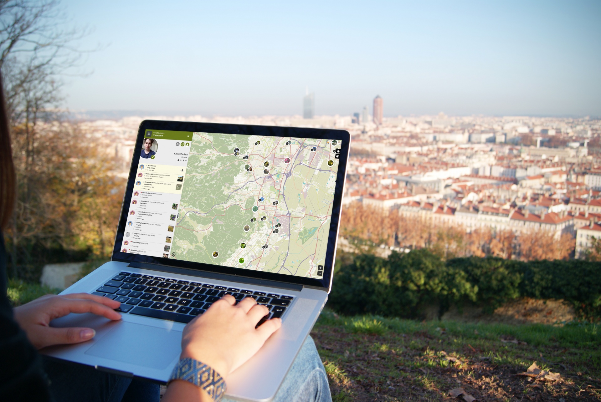
FULL FEATURE INTERACTIVE MAPS

As already a part of the common SPOTTERON packages A and B, the interactive map offers the same functionality as the smartphone apps, but in the desktop environment. From submitting own observations to the innovative SPOTTERON community features - the interactive map includes almost every tool and extension which the apps also already offer. The maps can be easily embedded in every project homepage and offer a seemless project experience for the Citizen Scientists.

The main difference are the monthly costs:
We can offer the new package L at a much smaller price-tag, since the whole work-package of constantly maintaining smartphone applications for Android and iOS can be dropped.

Ideal for smaller Citizen Science projects, the SPOTTERON package L enables to run your own community science on a high quality basis with many innovative features for researchers and Citizen Scientists alike. For sure, all interactive map projects are also constantly supported by our team and receive all SPOTTERON updates and upcoming extensions of the digital ecosystem of the platform.

You can find real-life examples of the interactive map "in action" here:


 Project Naturkalender Icon    Project Crowdwater Icon    Project Roadkill Icon
Nature's Calendar
 

Crowdwater


Roadkill

Topic: Phenology Citizen Science | Climate Research
Partner: ZAMG, Austria
  Topic: Hydrology Citizen Science
Partner: University Zurich, Switzerland
  Topic: Ecology | Road Safety
Partner: University for Life Sciences, Austria

OPEN MAP
   
OPEN MAP
   
OPEN MAP


GET THE SPOTTERON PACKAGE L WITHOUT SETUP FEE

To celebrate the official launch of the new SPOTTERON Package L for Citizen Science, we want to offer this web-based toolkit with all features of the SPOTTERON platform without the regular setup fee to the first 2 projects! Interested? Let's get in contact!

Projects & Apps open for Co-Use on SPOTTERON

App Icon
Social initiative Data Collection App
SPOTTERON

ArtSpots is a community-built art atlas. Through the App, people interested in various art forms like street art, historical or contemporary art, photography, architecture, and more can put their art observations on the map and discover art spots in their city or while travelling. The art community in the App allows exchanging with other like-minded people and contributing to a worldwide art collection.
Learn more about
ArtSpots
App Icon
Horizon Europe Citizen Science App

With the COSEA App, Citizen Scientists can observe marine environments, document coastal habitats or species, and report on pollution, infrastructure and the blue economy. Their contributions on the map and activity in the app will help scientists better understand the impacts and drivers of marine factors to protect and foster a healthy relationship between humans and seas.

Learn more about
COSEA | Collaboration for Effective Sea Action
App Icon
Environmental Citizen Science, Data Collection App
SPOTTERON

NatureSpots is a non-commercial and free project to discover nature together. In the app, nature photos and sightings of animals, plants or mushrooms can be shared with the community on the map. The app is a new initiative for observing nature and taking part is very simple and straightforward. The app is free of advertising, does not track users and takes digital privacy seriously.

Learn more about
NatureSpots
App Icon
Social initiative Community Engagement App
SPOTTERON

The new citizen participation uses "Citizen Science" in their hometown and nationwide to get User's feedback on places. As a result, citizens are empowered to become active in a city worth living in to collect and share data themselves and to interact with scientists. This enables them to recognize the consequences of sealing, heat, water shortages, and a lack of biodiversity, and generally, how places in their own environment affect us all.

Learn more about
CIVO Citizen Voice
App Icon
Horizon 2020 Invasive Species Monitoring App

The IPM-Popillia Horizon 2020 project aims to address the challenge of a new risk to plant health in Europe's agriculture and food safety: the invasion of the Japanese Beetle, Popillia japonica. This invasive species was introduced accidentally to mainland Europe in 2014 and can quickly spread by transportation and trade. As a species with a wide range of feeding plants, P. japonica threatens the entire agricultural sector, urban landscapes, and biodiversity in invaded areas.

Learn more about
IPM Popillia | Integrated Pest Management of the Japanese Beetle
App Icon
Environmental Community Engagement App

Fridays for Future see itself as a horizontal, grassroots grassroots movement that acts apolitically and refers to science for the facts. To engage the global population more, this app was developed using SPOTTERON. The aim is to find out how the population perceives the climate crisis and which positive and negative emotions are associated with specific topics related to biodiversity and climate crisis.

Learn more about
FRIDAYS FOR FUTURE - Climate App

Are you interested in co-using existing Apps? Get in Contact!

Get in contact for co-use here


Short News

  • New study from BiciZen project: "BiciZen: Lessons in the Development of a Crowdsourcing Mobile App to Make Cities More Bikeable" published in Journal of Participatory Research Methods. More studies available under the publication page here.

    in Shortnews
  • Roadkill project has made wonderful short videos for the citizen scientists! The videos include the Roadkill App functions regarding how to confirm & comment on the spots and how to best take the photos for the project. The videos (in German) are available in the "Österreich forscht" blog here. 

    in Shortnews

Newsletter

Please enable the javascript to submit this form