Spot Updates Feature: Collect not only single occurrence data records, create timelines in your Citizen Science App!

Monday, 31 August 2020 18:56

What is the best way for a Citizen Scientist to observe a specific plant, landscape, place, etc. over a more extended period of time and gather valuable data during its course?

Our world is subject to constant change.
It establishes itself by constant development and evolution, triggered by events like human activity, climate change, erosion, or simply the changing of the seasons, and many more. These changes in observational data are not just a side effect, but they're often the primary focus for scientists and the research project.

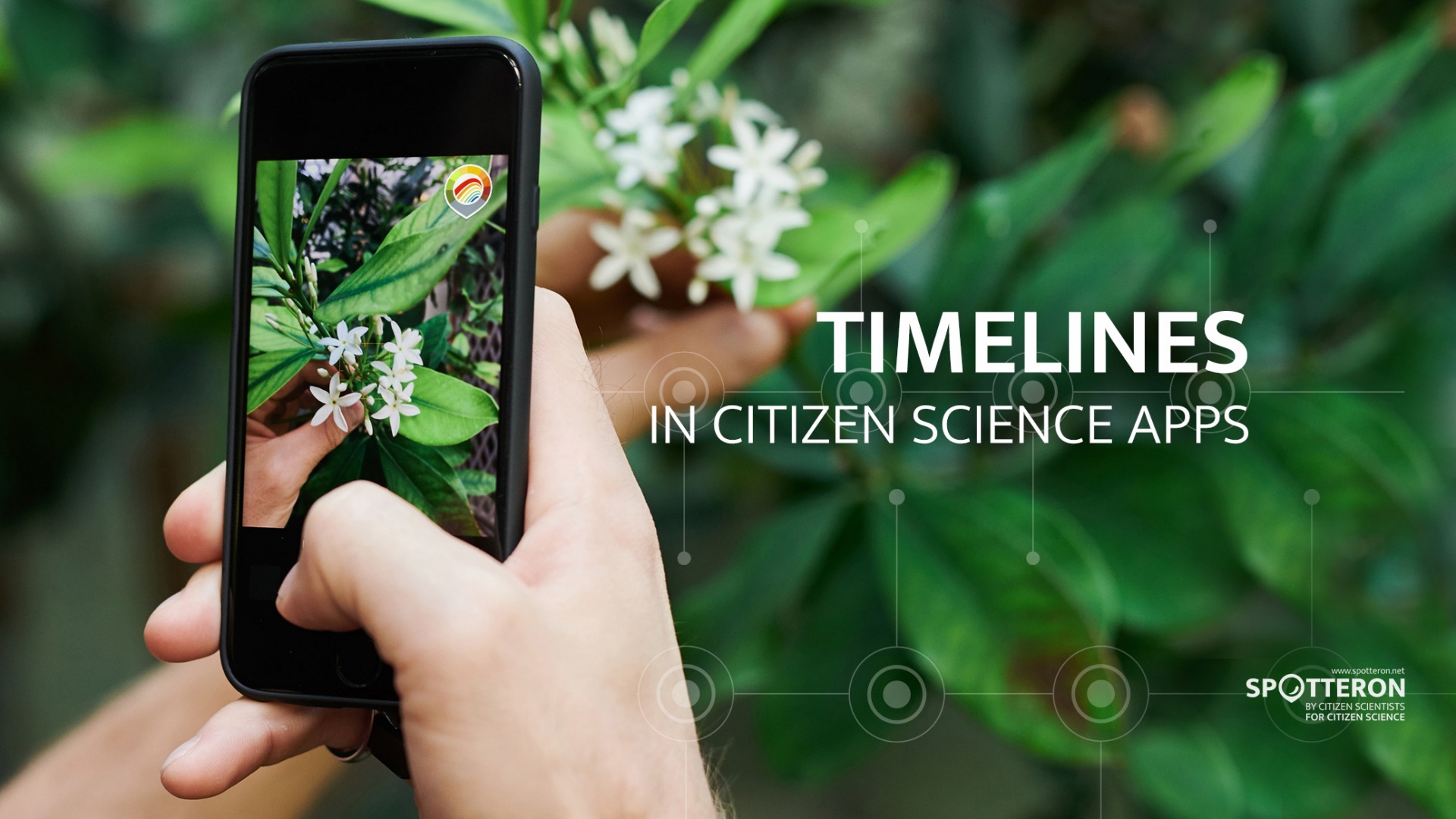
On the SPOTTERON platform, we've already created the "Spot Update" function to do precisely that: observing changes in things or locations over more extended periods, enabling Citizen Scientists to create timelines of one data entry. By updating the entry and adding new data over time, the development and changes of the subject can be documented.


Citizen Science App Design and Development

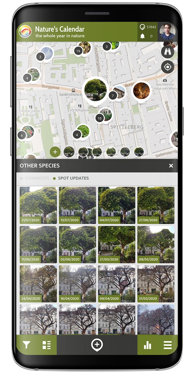
Practical examples for the Spot Update feature in Citizen Science include the phenology app "Natures' Calendar", where user groups such as garden owners, school classes, or nature enthusiasts can observe the life cycle of plants throughout the year, thus collecting valuable data for climate research. With this data, researchers can tell exactly how the seasons have shifted during the last 30 years, the springs in central Europe starting earlier, autumn lasting longer, and winters being milder.

Project Support and App Updates

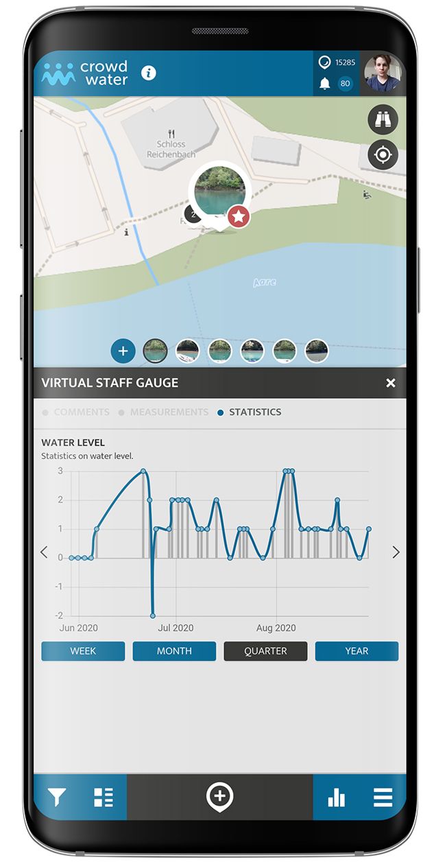
Another example is the "CrowdWater" app, where users interested in hydrology take photographs of rivers and streams to observe how they change due to, e.g. melting snow or weather, and provide the data basis for hydrological analysis and a community-driven flood warning system. The method can be applied in remote regions and developing countries to create a data basis. The data collected with CrowdWater can be used to complement existing measurement networks or to provide important information in areas without data.

Project Support and App Updates

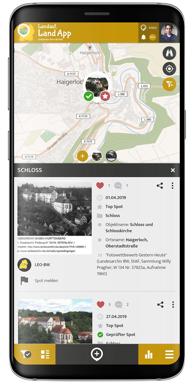
The "Landauf LandApp" project by the National Archie of Baden-Würtemmberg in Germany is a fine example of how to use the Spot Update feature in an exceptionally creative way. The Archive's historians have put up old black-and-white photographs of real locations, such as an ancient castle, a unique townhouse, or other landmarks, across the country on the map, and users revisited them to take pictures of the same object from the same angle and distance. Seeing the same view, the first historical version and then from modern times, was quite a sensation for both historians and local heritage.

Another attribute is the fact that users can add a Spot Update not only to their Spot, but also other users' Spot in the apps.
This not only helps the researchers with the collecting of data but is also fun and gratifying to users themselves to see their spots being updated by others, as it encourages Citizen Scientist to engage more with the app.

Even Better Spot Updating

Here at SPOTTERON, we pride ourselves on constantly developing new features and making improvements so that all our partners have smooth-running, reliable, and user-friendly apps to work with.
One such feature is the newly developed "Nearest Spot" feature. 

This new feature pops up at the beginning of any "Add Spot Dialogue" (when you want to contribute a new observation). The app then scans your surroundings, and, if there are any Spots nearby (your own or those of other users) the app will show them to you so that you can simply click on them and add your update - thus keeping the data clean, and users happy!
Alternatively, you can, of course, add a completely new Spot and start your own timeline. Read all about the new feature in full detail on the blog here: Better science data over time: introducing the Nearby-Spot feature

The SPOTTERON Feature Ecosystem for Citizen Science Apps

Funded by one of our partners, this newly developed feature is part of our unique Feature Ecosystem and available for free for all projects running on the SPOTTERON platform.

Projects & Apps open for Co-Use on SPOTTERON

App Icon
Social initiative Data Collection App
SPOTTERON

ArtSpots is a community-built art atlas. Through the App, people interested in various art forms like street art, historical or contemporary art, photography, architecture, and more can put their art observations on the map and discover art spots in their city or while travelling. The art community in the App allows exchanging with other like-minded people and contributing to a worldwide art collection.
Learn more about
ArtSpots
App Icon
Horizon Europe Citizen Science App

With the COSEA App, Citizen Scientists can observe marine environments, document coastal habitats or species, and report on pollution, infrastructure and the blue economy. Their contributions on the map and activity in the app will help scientists better understand the impacts and drivers of marine factors to protect and foster a healthy relationship between humans and seas.

Learn more about
COSEA | Collaboration for Effective Sea Action
App Icon
Environmental Citizen Science, Data Collection App
SPOTTERON

NatureSpots is a non-commercial and free project to discover nature together. In the app, nature photos and sightings of animals, plants or mushrooms can be shared with the community on the map. The app is a new initiative for observing nature and taking part is very simple and straightforward. The app is free of advertising, does not track users and takes digital privacy seriously.

Learn more about
NatureSpots
App Icon
Social initiative Community Engagement App
SPOTTERON

The new citizen participation uses "Citizen Science" in their hometown and nationwide to get User's feedback on places. As a result, citizens are empowered to become active in a city worth living in to collect and share data themselves and to interact with scientists. This enables them to recognize the consequences of sealing, heat, water shortages, and a lack of biodiversity, and generally, how places in their own environment affect us all.

Learn more about
CIVO Citizen Voice
App Icon
Horizon 2020 Invasive Species Monitoring App

The IPM-Popillia Horizon 2020 project aims to address the challenge of a new risk to plant health in Europe's agriculture and food safety: the invasion of the Japanese Beetle, Popillia japonica. This invasive species was introduced accidentally to mainland Europe in 2014 and can quickly spread by transportation and trade. As a species with a wide range of feeding plants, P. japonica threatens the entire agricultural sector, urban landscapes, and biodiversity in invaded areas.

Learn more about
IPM Popillia | Integrated Pest Management of the Japanese Beetle
App Icon
Environmental Community Engagement App

Fridays for Future see itself as a horizontal, grassroots grassroots movement that acts apolitically and refers to science for the facts. To engage the global population more, this app was developed using SPOTTERON. The aim is to find out how the population perceives the climate crisis and which positive and negative emotions are associated with specific topics related to biodiversity and climate crisis.

Learn more about
FRIDAYS FOR FUTURE - Climate App

Are you interested in co-using existing Apps? Get in Contact!

Get in contact for co-use here


Short News

  • New study from BiciZen project: "BiciZen: Lessons in the Development of a Crowdsourcing Mobile App to Make Cities More Bikeable" published in Journal of Participatory Research Methods. More studies available under the publication page here.

    in Shortnews
  • Roadkill project has made wonderful short videos for the citizen scientists! The videos include the Roadkill App functions regarding how to confirm & comment on the spots and how to best take the photos for the project. The videos (in German) are available in the "Österreich forscht" blog here. 

    in Shortnews

Newsletter

Please enable the javascript to submit this form