Introducing the Citizen Science Apps: RoadKill

Tuesday, 08 October 2019 16:00

In this blog series we would like to introduce all our apps and give you an overview of the diverse world of Citizen Science and its possibilities.

Today's App: Roadkill


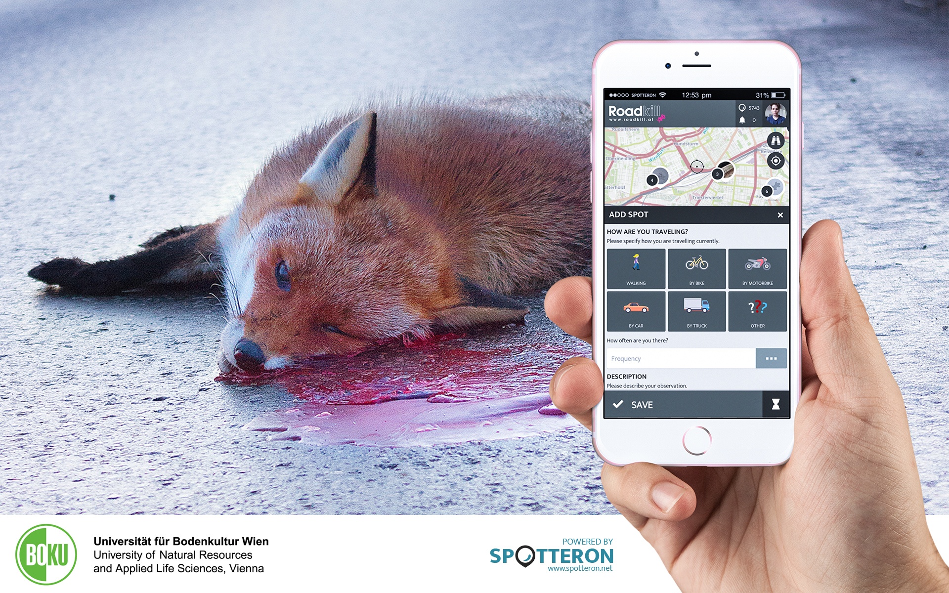
The Citizen Science project Roadkill of the BOKU (University of Natural Resources and Applied Life Sciences, Vienna) collects data about which animals are killed on the streets worldwide and why. This data then identifies hotspots in order to defuse those them.

How does roadkill happen?

Roads cut through natural habitats of many species. This phenomenon is referred to as habitat fragmentation, and describes the emergence of discontinuities (fragmentation) in an organism's preferred environment (habitat), causing population fragmentation and ecosystem decay.
On their search for food or mating partners (e.g. deer that travel long distances in the autumn in search of mating partners) or when switching between winter and summer quarters (e.g. toad migration in spring), animals often have to cross roads. These are especially affected by roadkill.

But roadkill is also relevant for us humans: "Animals on the road are a great danger and also a great ethical burden for motorists. Not only collisions with large wild animals such as deer, wild boar, etc. cause personal and property damage every year. Small animals such as hedgehogs and toads can also cause damage as accidents happen again and again due to change and braking maneuvers. " - the initiators told us.

The project's goal is to reduce roadkill as much as possible by finding the factors that determine it.

First and foremost, it is crucial to get an overview of the number and distribution of roadkills. The use of citizen science makes it possible to study large areas and to determine when (weather, season, etc.), where (forest, urban area, field, etc.) and on which type of road which species is killed.

Then roadkill hotspots can be identified and mitigated in cooperation with local authorities and NGOs.

These surveys will enable car drivers to warn of road-km hotspots (road sections with a high density of roadkills per year), depending on location and season, by implementing the data in navigation devices.

In addition, the Roadkill project raises awareness among participants about habitat fragmentation and provides public knowledge on where roadkills are taking place.


Download and try out the citizen science App here:

Android: https://play.google.com/store/apps/details?id=com.spotteron.roadkill
IOS: https://apps.apple.com/us/app/roadkill-spotteron/id1007563102
Web-App for Browser: https://www.spotteron.com/roadkill

Offical website: https://roadkill.at

Live Citizen Science Map Application of Roadkill


Projects & Apps open for Co-Use on SPOTTERON

App Icon
Social initiative Data Collection App
SPOTTERON

ArtSpots is a community-built art atlas. Through the App, people interested in various art forms like street art, historical or contemporary art, photography, architecture, and more can put their art observations on the map and discover art spots in their city or while travelling. The art community in the App allows exchanging with other like-minded people and contributing to a worldwide art collection.
Learn more about
ArtSpots
App Icon
Horizon Europe Citizen Science App

With the COSEA App, Citizen Scientists can observe marine environments, document coastal habitats or species, and report on pollution, infrastructure and the blue economy. Their contributions on the map and activity in the app will help scientists better understand the impacts and drivers of marine factors to protect and foster a healthy relationship between humans and seas.

Learn more about
COSEA | Collaboration for Effective Sea Action
App Icon
Environmental Citizen Science, Data Collection App
SPOTTERON

NatureSpots is a non-commercial and free project to discover nature together. In the app, nature photos and sightings of animals, plants or mushrooms can be shared with the community on the map. The app is a new initiative for observing nature and taking part is very simple and straightforward. The app is free of advertising, does not track users and takes digital privacy seriously.

Learn more about
NatureSpots
App Icon
Social initiative Community Engagement App
SPOTTERON

The new citizen participation uses "Citizen Science" in their hometown and nationwide to get User's feedback on places. As a result, citizens are empowered to become active in a city worth living in to collect and share data themselves and to interact with scientists. This enables them to recognize the consequences of sealing, heat, water shortages, and a lack of biodiversity, and generally, how places in their own environment affect us all.

Learn more about
CIVO Citizen Voice
App Icon
Horizon 2020 Invasive Species Monitoring App

The IPM-Popillia Horizon 2020 project aims to address the challenge of a new risk to plant health in Europe's agriculture and food safety: the invasion of the Japanese Beetle, Popillia japonica. This invasive species was introduced accidentally to mainland Europe in 2014 and can quickly spread by transportation and trade. As a species with a wide range of feeding plants, P. japonica threatens the entire agricultural sector, urban landscapes, and biodiversity in invaded areas.

Learn more about
IPM Popillia | Integrated Pest Management of the Japanese Beetle
App Icon
Environmental Community Engagement App

Fridays for Future see itself as a horizontal, grassroots grassroots movement that acts apolitically and refers to science for the facts. To engage the global population more, this app was developed using SPOTTERON. The aim is to find out how the population perceives the climate crisis and which positive and negative emotions are associated with specific topics related to biodiversity and climate crisis.

Learn more about
FRIDAYS FOR FUTURE - Climate App

Are you interested in co-using existing Apps? Get in Contact!

Get in contact for co-use here


Short News

  • New study from BiciZen project: "BiciZen: Lessons in the Development of a Crowdsourcing Mobile App to Make Cities More Bikeable" published in Journal of Participatory Research Methods. More studies available under the publication page here.

    in Shortnews
  • Roadkill project has made wonderful short videos for the citizen scientists! The videos include the Roadkill App functions regarding how to confirm & comment on the spots and how to best take the photos for the project. The videos (in German) are available in the "Österreich forscht" blog here. 

    in Shortnews

Newsletter

Please enable the javascript to submit this form