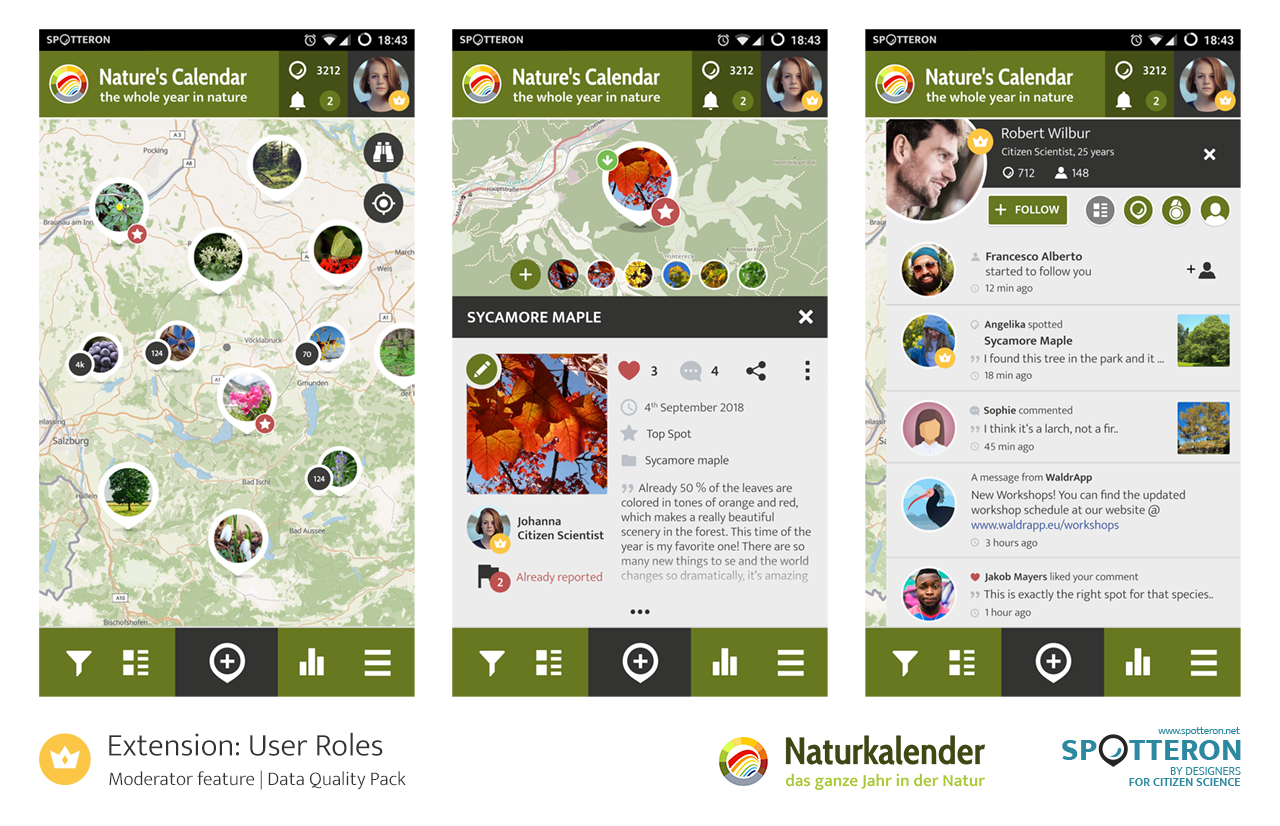
A new version release! SPOTTERON 2.6.0 includes User Roles, Flagging and Data Download for all Citizen Science Apps

Monday, 18 February 2019 17:28

We are happy to announce the release of the new SPOTTERON version 2.6.0! The next SPOTTERON Update brings 3 new extension, available for all Citizen Science apps running on the SPOTTERON platform. In the following blog entry we are going to explain these new features and their function.

User Roles

Data Quality is always an important part in running a Citizen Science project, and sometimes observations of the users don't match that. For example, the location can be off or the classification can be wrong. To improve data quality and also involve more experienced users on a deeper level, we have introduced the new "User role" feature.

With this new functionality for all Citizen Science apps on the SPOTTERON platform, the admins of a project can promote trusted users to "moderators" in the administration interface. These moderator users can now edit the submitted data of other Citizen Scientists in the app and correct information, fine-tune the location or change the classification if a species is wrong in an observation. Moderator users get an unique icon in their profile picture (crown icon) and regular users, whose spots get edited by a moderator, will recieve a notification in the news-feed panel in the Citizen Science app.

In the Administration interface, the user role of a Citizen Scientist will also be visible for the project's scientists and regular users can be promoted to moderators directly in the spot list. The "User Roles" feature is an important step forward to increase the data quality while reducing the workload of the project scientists.For the moderator users themselves, it is also a motivational benefit to be able to share their knowledge and help with the Citizen Science project's data.
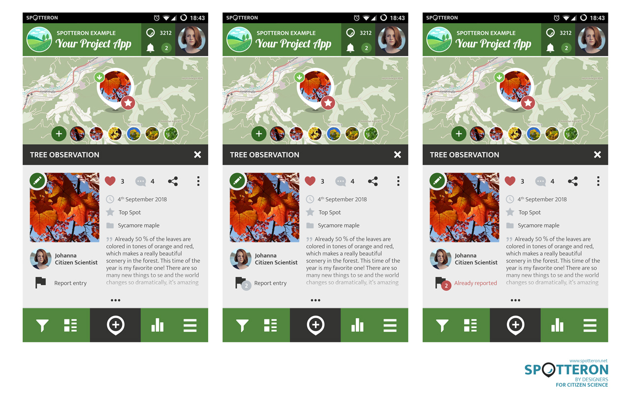
SPOTTERON Naturkalender UserRoles 1280px

Flagging

The second feature of the 2.6.0 version of the SPOTTERON Platform is called "Flagging". Citizen scientists can mark wrong or controversial entries by simply pressing the new flag button, which is present at every detail spot in the apps.

Those "flags" are also visible directly in the spot list in the Administration Interface, where the project team can always access and filter the data. the amount of flags is listed per spot in the list view and administrators of a project have the option to sort the list by that. With the help of the community the project's admins can now check the data more efficiant and save time, which is especially important if a Citizen Science has many contributions per day. After reviewing a flagged spots, the admin users can also reset the number of flag to zero with one click.
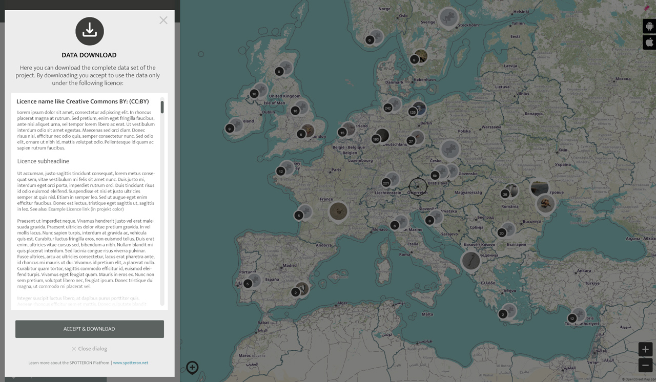
Apps v2 study42 FlaggingPreview Full 1280px

Data Download

Last but not at least, the "Data Download" feature is providing an easy methode to publish a project's dataset as "Open Data" to the public.This feature is already available on the Web App of the CrowdWater Project after loggin in (www.spotteron.com/crowdwater) and everyone with a user account in the project can download the data for their own research or analysis.

The "Data Download" extension has a license dialogue attached to it, which can be configured individually per project. The license under which the data of a project can be shared is displayed in the new dialog and must be accepted before the data can be downloaded. We suggest to use the Open Database Licence "ODbL", which allows a free data usage of the data set without the necessity to quote each individual contributor in contrast to the Creative Common CC:BY license. The "Data Download" feature is not for evcery project on the SPOTTERON Citizen Science platform - but for those who want to publish their contributions as Open Data, it is a big improvement.

SPOTTERON iFrameMap Preview DataDownload 1280px


Projects & Apps open for Co-Use on SPOTTERON

App Icon
Social initiative Data Collection App
SPOTTERON

ArtSpots is a community-built art atlas. Through the App, people interested in various art forms like street art, historical or contemporary art, photography, architecture, and more can put their art observations on the map and discover art spots in their city or while travelling. The art community in the App allows exchanging with other like-minded people and contributing to a worldwide art collection.
Learn more about
ArtSpots
App Icon
Horizon Europe Citizen Science App

With the COSEA App, Citizen Scientists can observe marine environments, document coastal habitats or species, and report on pollution, infrastructure and the blue economy. Their contributions on the map and activity in the app will help scientists better understand the impacts and drivers of marine factors to protect and foster a healthy relationship between humans and seas.

Learn more about
COSEA | Collaboration for Effective Sea Action
App Icon
Environmental Citizen Science, Data Collection App
SPOTTERON

NatureSpots is a non-commercial and free project to discover nature together. In the app, nature photos and sightings of animals, plants or mushrooms can be shared with the community on the map. The app is a new initiative for observing nature and taking part is very simple and straightforward. The app is free of advertising, does not track users and takes digital privacy seriously.

Learn more about
NatureSpots
App Icon
Social initiative Community Engagement App
SPOTTERON

The new citizen participation uses "Citizen Science" in their hometown and nationwide to get User's feedback on places. As a result, citizens are empowered to become active in a city worth living in to collect and share data themselves and to interact with scientists. This enables them to recognize the consequences of sealing, heat, water shortages, and a lack of biodiversity, and generally, how places in their own environment affect us all.

Learn more about
CIVO Citizen Voice
App Icon
Horizon 2020 Invasive Species Monitoring App

The IPM-Popillia Horizon 2020 project aims to address the challenge of a new risk to plant health in Europe's agriculture and food safety: the invasion of the Japanese Beetle, Popillia japonica. This invasive species was introduced accidentally to mainland Europe in 2014 and can quickly spread by transportation and trade. As a species with a wide range of feeding plants, P. japonica threatens the entire agricultural sector, urban landscapes, and biodiversity in invaded areas.

Learn more about
IPM Popillia | Integrated Pest Management of the Japanese Beetle
App Icon
Environmental Community Engagement App

Fridays for Future see itself as a horizontal, grassroots grassroots movement that acts apolitically and refers to science for the facts. To engage the global population more, this app was developed using SPOTTERON. The aim is to find out how the population perceives the climate crisis and which positive and negative emotions are associated with specific topics related to biodiversity and climate crisis.

Learn more about
FRIDAYS FOR FUTURE - Climate App

Are you interested in co-using existing Apps? Get in Contact!

Get in contact for co-use here


Short News

  • New study from BiciZen project: "BiciZen: Lessons in the Development of a Crowdsourcing Mobile App to Make Cities More Bikeable" published in Journal of Participatory Research Methods. More studies available under the publication page here.

    in Shortnews
  • Roadkill project has made wonderful short videos for the citizen scientists! The videos include the Roadkill App functions regarding how to confirm & comment on the spots and how to best take the photos for the project. The videos (in German) are available in the "Österreich forscht" blog here. 

    in Shortnews

Newsletter

Please enable the javascript to submit this form