SPOTTERON
Green Growth Forests - A new Citizen Science App on the SPOTTERON platform
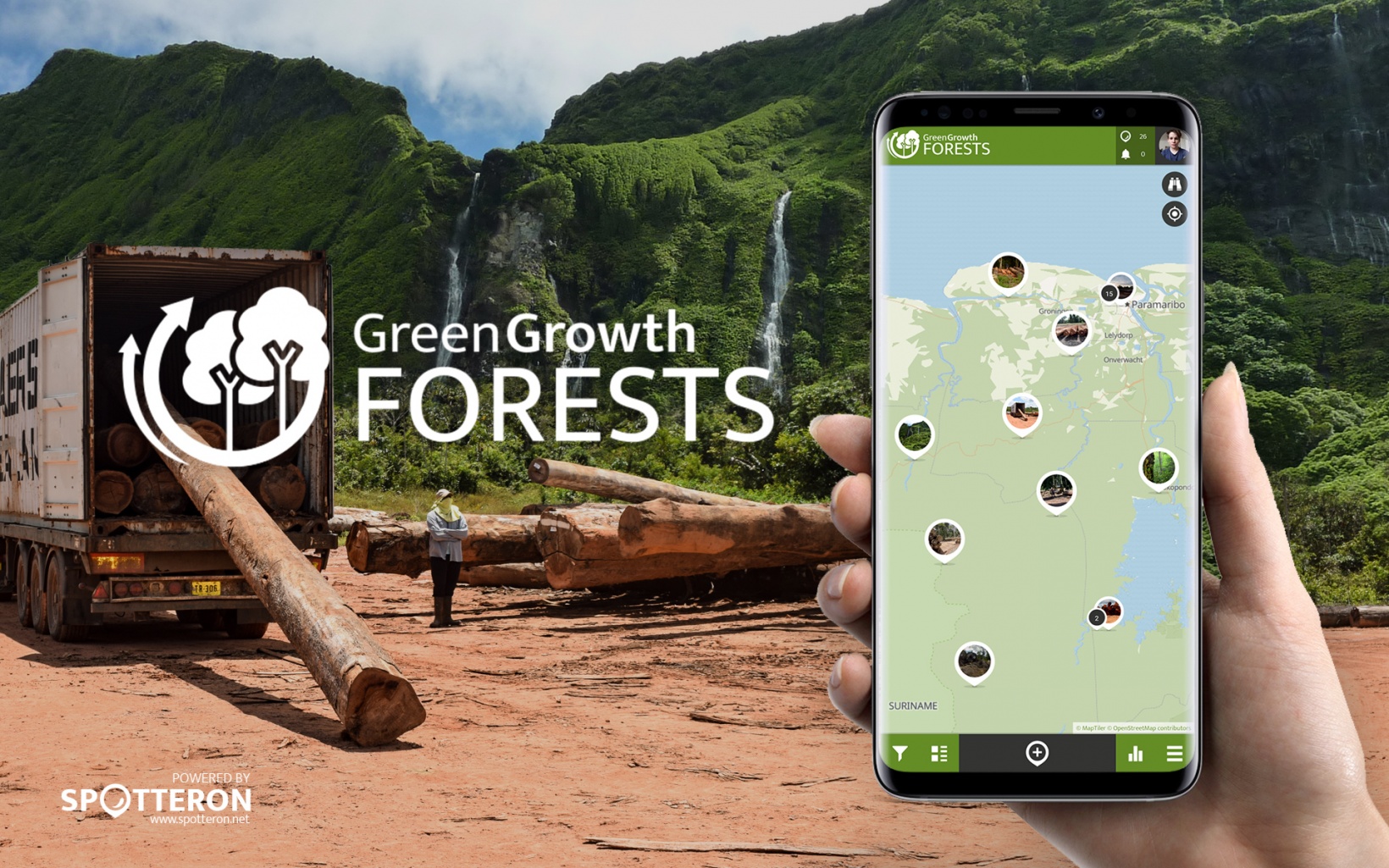
Green Growth Forests is another new app on the SPOTTERON citizen science platform and the first project from South America!
Big City Birds
The Big City Birds Citizen Science App aims to learn about five specific bird species and their behavioral adaptations to living in the city. Their whereabouts, behaviors, communal roosts, and nest sites are of interest to researchers at the Max Planck Institute of Animal Behavior, the National Australian University, and The University of Sydney. The data collected will help scientists understand these species’ behavior, movement, reproduction, distribution, and habitat use in suburban areas.
Our Outdoors

Our Outdoors is a citizen science project which aims to find out more about what users experience when they are in public spaces such as parks, beaches, canals, and town squares. It was developed by researchers in the Scottish Collaboration of Public Health Research and Practice (SCPHRP) at the University of Edinburgh in partnership with Sustrans, the MRC and citizens.
Cane Toad Challenge
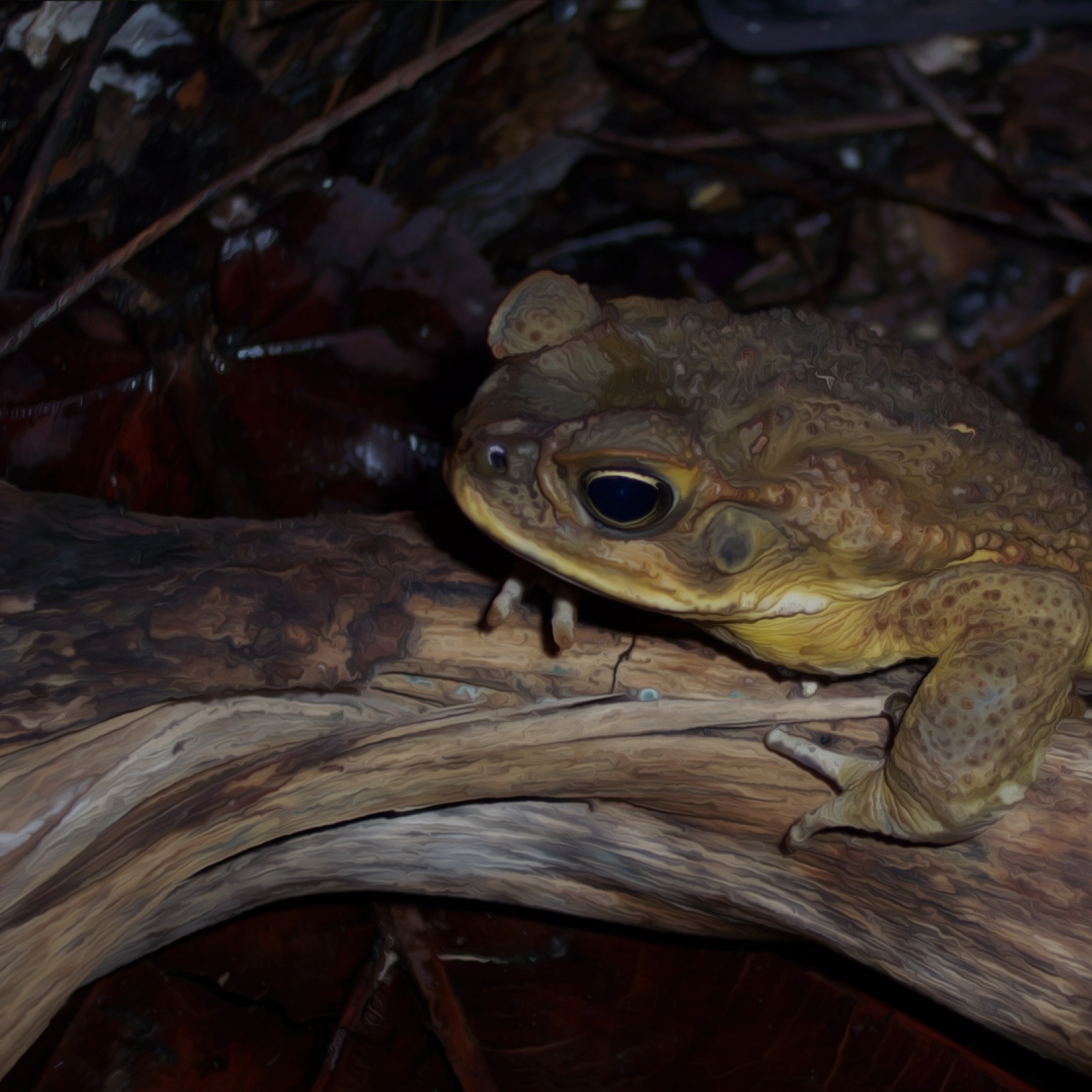
Cane toads are relentless invaders. Native to Central America, cane toads were transported to sugar cane growing regions of the world early last century, including Australia, in the hope they would eat and eradicate beetles devastating sugar cane crops. The experiment failed spectacularly. Toads ignored beetles, and instead embarked on an epic global invasion.
Green Growth Forests
With the Green Growth app everyone can contribute to keeping Suriname the greenest country on earth with 93% forest cover. The data will help to manage the forests of South America. This Citizen Science project aims to create an active community of forest watchers and keep Suriname green.
SIBRA

The connections between water and geological underground are diverse and often complex. Using the SIBRA App, citizens can generate reliable data on these topics and thus contribute to a better understanding of these connections. At the Geological Survey of Austria, the data is being combined with other methods of measurement and used, inter alia, in developing models and scenarios that allow for assessing possible effects of extreme weather events, such as heavy precipitation, rapid snowmelt, flooding or draught.
Hey Citizen Scientists, wanna to name some Northern Bald Ibis Chicks?
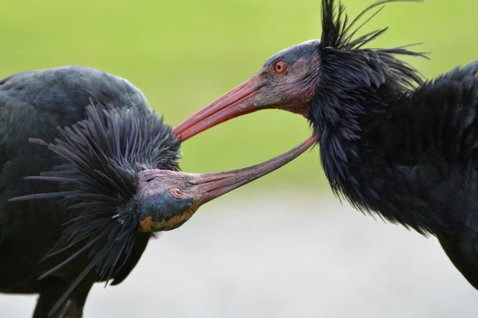
Our Citizen Science partner "Konrad Lorenz Research Center", running the Citizen Science App "Forschen im Almtal" on the SPOTTERON Platform and initiator of "NestCams", our first collaboration with Zooniverse, started a great initiative. At their research station, they host a colony of Northern Bald Ibis, amazing birds which you can also observe in the "Forschen I'm Almtal" Citizen Science App.
Tiergarten Schönbrunn Vienna

Tiergarten Schönbrunn (literally, "Schönbrunn Animal Garden"), or "Vienna Zoo", is a zoo located on the grounds of the famous Schönbrunn Palace in Vienna, Austria. Founded as an imperial menagerie in 1752, it is the oldest continuously operating zoo in the world.
Today, Tiergarten Schönbrunn is considered and regards itself as a scientifically administered zoo which sees its main purpose as a centre for species conservation and general nature conservation as well as in the fulfillment of the education mandate given to it by the legislation. The still preserved buildings of the baroque era, which have been complemented in the last years by elements of modern zoo architecture, still convey a good impression of the 18th century menagerie-buildings after the Versailles model.
University of Glasgow
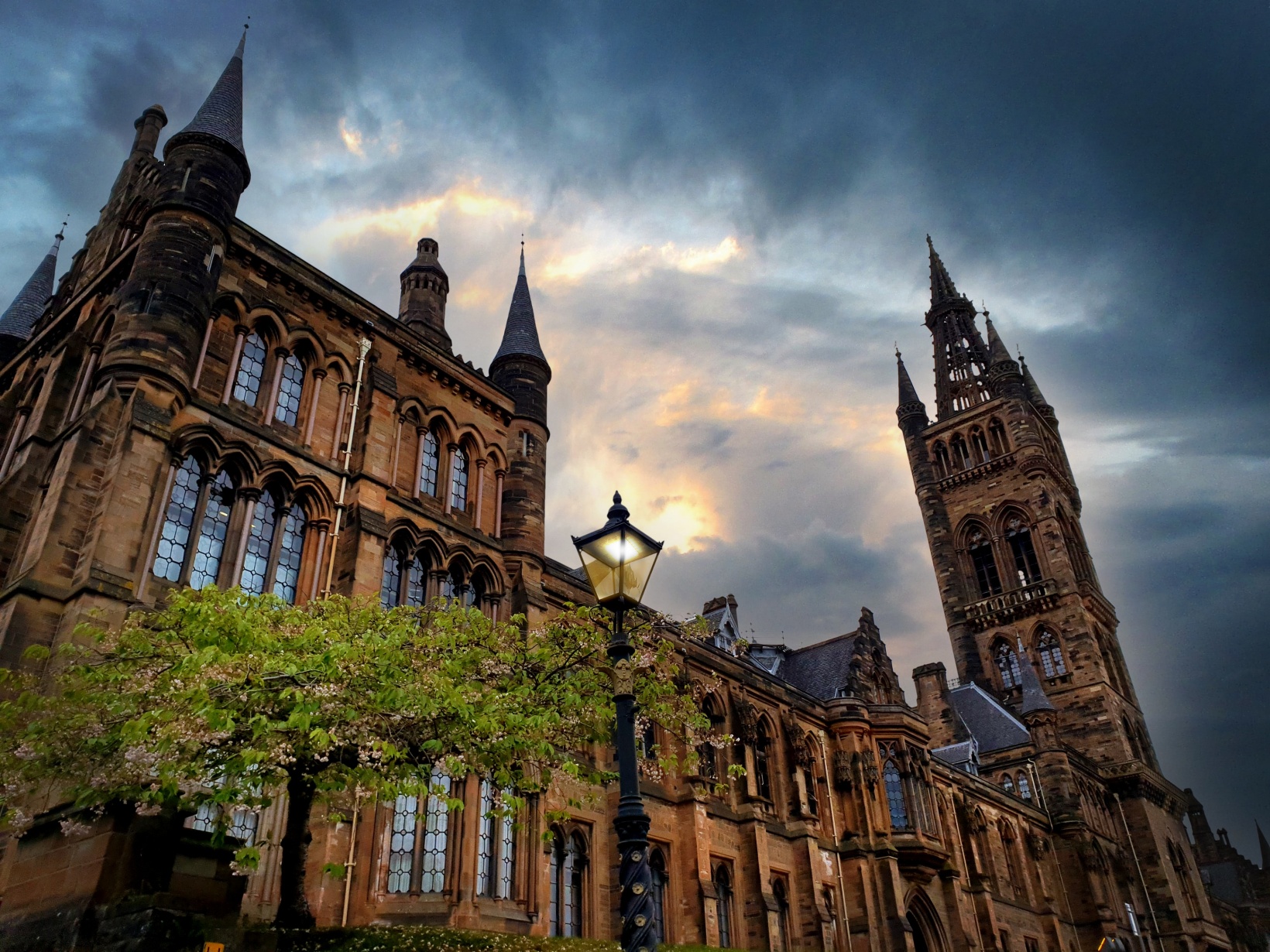
The University of Glasgow (abbreviated as Glas. in post-nominals) is a public research university in Glasgow, Scotland. Founded by papal bull in 1451, it is the fourth-oldest university in the English-speaking world and one of Scotland's four ancient universities. Along with the universities of Edinburgh, Aberdeen, and St Andrews, the university was part of the Scottish Enlightenment during the 18th century.
New Citizen Science Apps: Spot-a-Bee & KraMobil
Two more Citizen Science Apps have been added to the SPOTTERON Citizen Science App section! With Spot-a-Bee you can observe bee species to understand better, which flowers the favour, and with KraMobil, you can observe crows for ornithology and behavioural science. Enjoy!
Projects & Apps open for Co-Use on SPOTTERON

ArtSpots


With the COSEA App, Citizen Scientists can observe marine environments, document coastal habitats or species, and report on pollution, infrastructure and the blue economy. Their contributions on the map and activity in the app will help scientists better understand the impacts and drivers of marine factors to protect and foster a healthy relationship between humans and seas.
COSEA | Collaboration for Effective Sea Action


NatureSpots is a non-commercial and free project to discover nature together. In the app, nature photos and sightings of animals, plants or mushrooms can be shared with the community on the map. The app is a new initiative for observing nature and taking part is very simple and straightforward. The app is free of advertising, does not track users and takes digital privacy seriously.
NatureSpots

The new citizen participation uses "Citizen Science" in their hometown and nationwide to get User's feedback on places. As a result, citizens are empowered to become active in a city worth living in to collect and share data themselves and to interact with scientists. This enables them to recognize the consequences of sealing, heat, water shortages, and a lack of biodiversity, and generally, how places in their own environment affect us all.
CIVO Citizen Voice

The IPM-Popillia Horizon 2020 project aims to address the challenge of a new risk to plant health in Europe's agriculture and food safety: the invasion of the Japanese Beetle, Popillia japonica. This invasive species was introduced accidentally to mainland Europe in 2014 and can quickly spread by transportation and trade. As a species with a wide range of feeding plants, P. japonica threatens the entire agricultural sector, urban landscapes, and biodiversity in invaded areas.
IPM Popillia | Integrated Pest Management of the Japanese Beetle

Fridays for Future see itself as a horizontal, grassroots grassroots movement that acts apolitically and refers to science for the facts. To engage the global population more, this app was developed using SPOTTERON. The aim is to find out how the population perceives the climate crisis and which positive and negative emotions are associated with specific topics related to biodiversity and climate crisis.
FRIDAYS FOR FUTURE - Climate App